Nancy & Ruben's
California Coast Vacation '99

Also check out new pictures of Laguna Beach, with their art festival, also Pismo Beach,with a Volley Ball Championship, Oceano Beach, Santa Barbara w/ art fair and park festival, and nearby Piadaro Beach, with cool rock formations.
Part - 1 -
Yosemite National Park
California Coast Vacation |
Page 1 - Yosemite |
Page 2 - S.F. & Fort Bragg |
Page 3 - Fort Bragg & Mendocino |
Page 4 - Berkeley to Santa Cruz |
Page 5 - Santa Cruz, Monterey, Carmel, Big Sur |
Page 6 - Cayucus, Morro Bay, Port San Louis, Pismo Beach |
Pre-Photos |
After-Photos |
With Frames |
Escape Frames
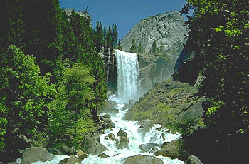
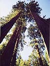
Yosemite Picture From The Brochure
Monday evening, Sept 6
- Monday afternoon Nancy got off work a little early, so we left Los Angeles north towards Yosemite National Park about 5 pm. I'd already picked up the rent a car from Budget (1-800-601-5385) and it was a burgandy Ford Contour. They didn't have the Toyota Corrola they said they would, but the Contour was fine.
We headed out of town going north on the 5 to Bakersfield. We wound through the "grapevine" (mountains above Magic Mountain) and down the other side to Bakersfield. Once over the mountain, the air was warmer and drier, and if felt good. I could soak in it for awhile, but Nancy said it was too hot. Approaching Bakersfield, we branched off the 5 to the ?, which went through such places as "Weedpatch" on it's way through Bakerfield and on to Fresno. We ate dinner in Bakersfield at a nice family restaurant. The family next to us wore cowboy hats, or at least the older ones, and I realilzed we were in cowboy country.
On the road again, we headed towards Fresno, where we would catch the 41 North/East to Yosemite. We planned on filling up with gas in Fresno, but the 41 freeway came first, and then heading out of town, the prices were going up dramatically. I'd recommend filling up just before the 41 and "saving a buck or two".
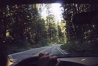
The Road To Yosemite
Anyway, we headed up 41 into the mountains towards our destination of Yosemite. I knew very little about Yosemite as I'd never been there before, so we followed the map to the town of Oakhurst, which is the town just before entering Yosemite National Park from the south. As we drove on through the night, the road got more winding and hilly, and soon we were in california mountain country.
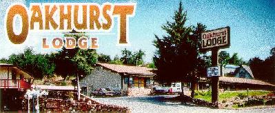
On finally arriving in Oakhurst, still 1/2 hour from Yosemite, we stopped for directions & advice at the only gas station, where they recommended the Ramada, which we called and found out was about $79 per night plus tax, as opposed to our planned destination of the Oakhurst Lodge. It was $70.85 weeknights with tax and AAA discount and located at 40302 Highway 41, Oakhurst, CA 93644, Phone 559-683-4417, or 800-655-6343. It was OK, but the swimming pool was cold and it was kinda funky. I didn't sleep good on the bouncy bed, but the continental breakfast in the morning was ok and so we saved a little.
Tuesday, Sept 7
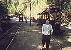
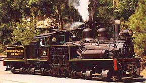
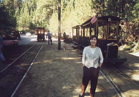
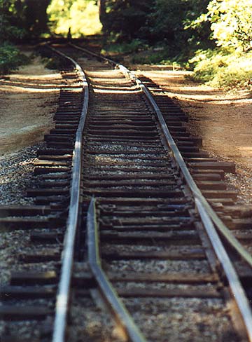
We headed back onto the 41, stopping briefly at a place called the Yosemite Information Center, where they offered little advice, only books for $30 and such. We headed on up the mountain, and saw the billboards for the Yosemite Mountain Sugar Pine Railroad, so we decided to stop. It was a quarter to nine, and we were the first ones there (It was a tuesday). The brochure said a ride was at nine, so we took it, riding a trolly down the narrow gauge tracks through the 2nd growth redwoods to a picnic area down by the stream. We stopped for a minute to soak in the ambience, and then chugged back up the "Indiana Jones" rails up the mountain to the depot. It wasn't too exciting cause it was only a trolly, but when we were ready to leave, they pulled the steam engine out of the shed, where it was rumbling and hissing as it built up steam for it's first run of the day. Since the Musuem (shack) was closed, we headed on up into Yosemite. We past Fish Camp, which isn't really a town but more of a few buildings along the road, and I even saw the green Fish Camp cabins that looked so cool on the their website. (They're rates were considerably more) .
 -
-
 -
-
Yosemite's Sugar Pine Railroad (click for enlargement)
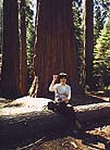
The road got steeper and the curves got sharper, and finally we came to the South Entrance to Yosemite. We paid our $20 per car, got our map, and asked for advice but got little. They said, the Redwoods are to the right and everything else is to the left. We went right first to the redwoods, where we took some pictures of the giant trees, and into the gift shop where we got the cool fat redwood tree pencils for abut $2 each. They said Yosemite where they sliced away some bark, and they were one of my favorite souveniers of Yosemite. They had a trolly tour through the redwood valley, which took an hour or so, but we had to wait for the next trolly to arrive and it was already nearing noon, so we got back in our trusty rent a car and headed north towards "everything else".
 -
-
Riding thru the Big Trees
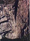
Looking at the map, we decided to go to "Yosemite Valley" where they had a "visitor's center." The road was long and winding and took forever but got more and more spectacular. We passed a sign that said "Glacier Point 18 miles" but stayed on our main road to the valley. On retrospect, we should have gone up to Glacier Point then, had we know we were going to come back up there anyway later. Anyway, we soon came upon the most amazing mountain cliffs I'd ever seen, and since I was building such mountain cliffs on my model railroad at home, I was held in wonderment of the formation of these natural mountains.
 -
-
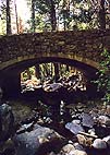
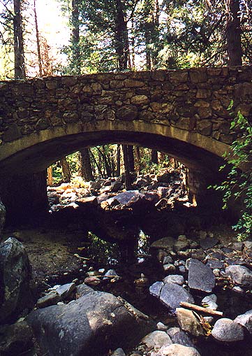
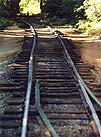
Yosemite Road & Secluded Bridge
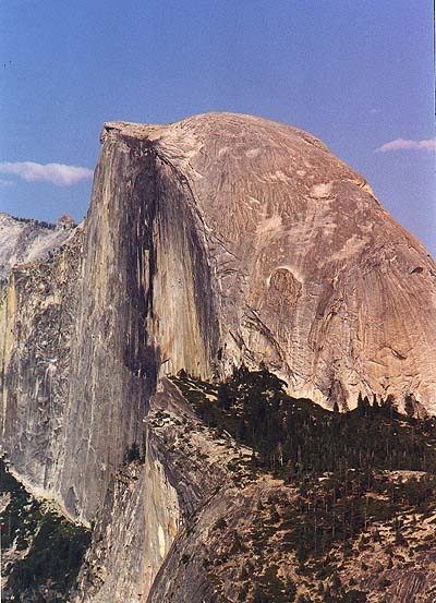
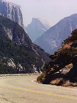
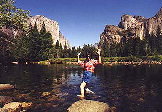
After going through a long tunnel, we came upon one of the most magnificent veiws I'd ever seen. It was the famous "half dome" mountain peak viewed through some other famous Yosemite mountain peaks and valleys. It was spectacular. There was a turnout viewing place where busloads of tourists were taking pictures of the famous sight. That's when we knew we were in "God's Country", perhaps, the most beautiful place on earth. This is where God himself lived. so we imagined. I'd seen lots of pictures of Yosemite National Park but didn't really know what it was like, just that is was a national park.
 -
-
So here's what it is. Yosemite is a giant valley set way up in the mountains behind San Francisco. The Yosemite National Park includes the valley and the mountains around the valley, which is huge. The valley floor is completely flat, with a giant beautiful river cascading through the middle. On either side are towering rock face cliffs that go up thousands of feet and are one of natures most beautiful shows. Between the moutain cliffs are smaller valleys and waterfalls of unbelievable height, each with it's own name. Rivers, streams, and 1 - 2 hour hikes up to and through. This is truly a hikers land, and since we only had one day, we had to keep hiking to a minimum. The next time we visit Yosemite, we plan on spending more time for hiking. It's also a long drive in and out of Yosemite as well as through it, almost more than it's worth for only one day. My back was sore from deadline and the constant driving through the winding mountain roads. I will say one thing. The roads were nice. Smooth as glass and black as coal with sharp white and yellow stripes and wide bright reflectors.
Anyway, You can drive through the valley floor, about half hour in and half hour out. along the way there are numerous places to stop and view the cliffs, mountains, cascading river, and the waterfalls. Inside there's "Yosemite Camp" where the visitors center is, and "Camp Noyo". You can stop at many places along the valley floor.
You can also drive around and up along the top of the mountain faces looking down into the valley and across at the wonder of the opposite valley wall. both sides are fantastic views, and you can see all the famous named mountain peaks and waterfalls from many different veiws. The many hiking trails go up to famous points or waterfalls from both the valley bottom and the ridge top. It's a hikers world, or photographers, or a painters, or anyone that just likes to be surrounded by the beauty of nature.
 -
-
We tried to stop at Yosemite Camp in the middle of the main valley, but all the parking lots were full with no sign to say there full, so there were hundreds of tourists driving around trying to find parking. Finally after 20 minutes of frustration, we found a lot, parked, and followed the sign to the "Visitors Center" . It was about a 20 minute hike to the visitor's center, through other parking lots and small paved roads with lost tourists, which was just about as much help as the one in Oakhurst. You could buy a map of the hiking trails for about $7.50, otherwise, you could go outside and look on the redwood "you are here" map, which were almost useless. We followed the signs to the "tours", which were expensive and somewhat long.
We decided to jump on the free shuttle and go around the loop. At first I though the loop was the in and out of the valley loop, but it's a different loop that goes around the inner campground section of the center of yosemite valley. We ended up catching the one that went back to the parking lot, where it waited about 10 long agonizing minutes at every stop. We finally got back to where we started, and stayed on to go to the rest of the shuttle places. Unfortunately they were all uneventful, just roads and parking lots and campgrounds, so the shuttle is not for sighseeing at all. Only for campers who don't have a car or tourists who can't figure out how many parking lots they have to hike through to find their car. I think Yosemite should really get their act together as far as helping first time tourists. For one-day visitors it may well be worth the $58 for the all day tour, cause they pick you up at your hotel and take you around with a guide.
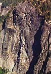 -
-
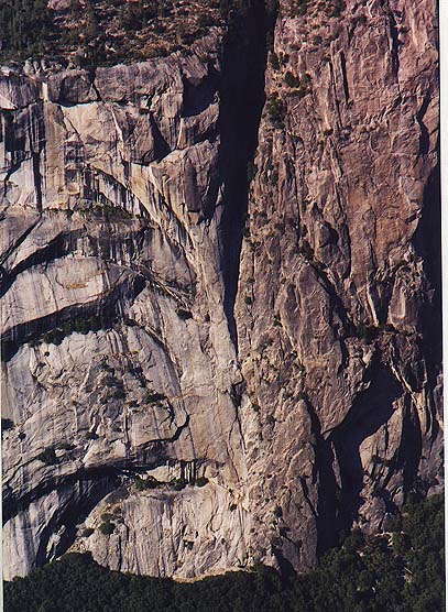
Yosemite Rock Faces (click for enlargement)
We decided to go to Glacier Point, where we had passed the road on the way in, so out we went, stopping to see a waterfall or two and dangle our feet in the rushing river from a fallen log. Along the way the scenery was fantastic in every direction. We saw the same beautiful views as on the way in, and the road up to Glacier Point was long but beautiful. We finally arrived at the top and what a top it was. Top of the world. You could walk up to a tourist lookout point, where you could see the entire Yosemite Valley and famous mountain points and falls. Halfdome Peak, directly across from us, looked like a giant eagle head, and you could see where the two main rivers came together in center of the valley. Waterfalls were here and there, but it was late summer and many were only small falls, not like the big gushers in the spring. there was a rock point that seemed to hang out over the valley, and if you stood on it and fell, you'd land about 3,000 feet down on somebody's campsite. Of course it was fenced off, but it wouldn't be hard to get out on it if you dared.
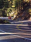
The ride up to Glacier point and back down took over an hour, and the road down and up the other side of the valley ridge would take all day, so we headed towards San Francisco. After leaving the main valley floor and winding down highway 41, to was still unbelievable beautiful as the sunset cast deep shadows and created misty hazy valleys of rock along the winding "California road". It took forever to get out of Yosemite. Even after we though we were out, it was another hour or so before we finally went through the West Entrance gate. Things didn't change much for the next 50 miles. Treacherous winding roads and a sign every 20 miles to let you know if you were going the right way.
For future reference, the "Yosemite Guide" newspaper was the only helpful literature we found. When we looked up camping sites on the web, they said you had to mail a request in to get a campsite. Well, we hardly had time to wait for return mail and then more mail, so camping seemed out of the question. However, in the "Yosemite Guide" they give you a direct phone number. It's 800-436-7275. or you can reserve them online at: reservations.nps.gov Camping reservations are made after the 15th of the month, starting at 7 AM, for up to 5 months in advance. The Yosemite Guide has a lot of information, and is very helpful but doesn't list an address or phone number to get a copy in advance. Maybe try The Yosemite Association or the National Park Service, or the Yosemite Concession Services Corp 209-372-8341.
If you want to take a tour, the prices are: Valley Floor: $17.50, Mariposa Grove of Big Trees: $34.50, or Tram: $8.50, Glacier Point $20.50 or $10.50 one way if you want to hike the 5 miles or more down to the floor. The Grand Tour full day: $45.25, or more info at http://www.yosemitepark.com
We stopped at the first place to eat we found, but should have gone another 5 miles to a fantastic little town called Groveland, I believe. This is definitely the place to stop if you're coming from San Francisco. A tiny village with many classic rustic cute little shops and cafe's to make you feel just right.
We drove on through the night till we hit Oakdale, the first main town with real hotels. We were tired, and went to the one that advertised $39 rooms on billboards, but of course those were filled months ago, and all they had was their $75 room. We went to the Comfort Inn we passed on the way into town, and their rate was $79 and a lot nicer and cleaner so we checked in. The Comfort Inn is just that, a comfort, everything from the atmosphere to the room to the bed to the pool to the jacuzzi was nice. Well worth the extra $4. I slept better tonight, maybe cause I was tired from driving all day. We were ready to visit San Francisco and drive north to Fort Bragg tomorrow.
The Road Out Of Yosemite
California Coast Vacation |
Page 1 - Yosemite |
Page 2 - S.F. & Fort Bragg |
Page 3 - Fort Bragg & Mendocino |
Page 4 - Berkeley to Santa Cruz |
Page 5 - Santa Cruz, Monterey, Carmel, Big Sur |
Page 6 - Cayucus, Morro Bay, Port San Louis, Pismo Beach |
Pre-Photos |
After-Photos |
With Frames |
Escape Frames


 -
-